The deserts and canyons of southern Utah and northern Arizona house an incredible number of landscape locations. It’s hard to know where to start when planning a trip. It’s an easy area to research as the Web is riddled with narrative and photographs that document more locations than anyone could possibly cover in years of travel. We decided that three to four weeks in May would give us the time to hit a selection of the roadside high points and a few of the more remote off road locations that, combined, would help to generate an overall feel for the area. We chose to get underway at Arches National Park on the outskirts of Moab as it is a setting that is easy to drive and has a host of sunrise and sunset locations that have the potential to generate some early excitement in our trip. Our plan was to slowly work our way south through Monument Valley Navajo Tribal Park to Page in Arizona where we fully intended to experience the frustration of Antelope Canyon, unarguably the most photographed slot canyon in the world. After working this and the environs around Glen Canyon, Horseshoe Bend, the Navajo Bridge and Cliff Dwellers, our goal was to get off road and experience the Stone House Valley and lower Cottonwood Canyon roads which traverse the Vermilion Cliffs and Grand Staircase Escalante National Monuments respectively. Exploring the latter area, we hoped to find and photograph the Wahweap Toadstools, a remote and largely unknown location that still remains a mystery to many of the locals. We then planned to stop at Kanab and take in the Coral Pink Sand Dunes State Park, a location that was recommended as having tremendous potential but is largely forgotten as a photography destination (more on this later). Traveling north, we dedicated two days to Bryce Canyon National Park with the objective of also completing the upper Cottonwood Canyon road to Grosvenor Arch and Kodachrome Basin State Park. We planned to wind up our excursion by wending our way through Capitol Reef National Park and Goblin Valley State Park. An ambitious agenda but laden with potential for well known and off road locations that makes for an exciting trip. You can see how we fared in Gallery 75 and read about the finer points of each location below.
As it’s roughly a three day drive from our home in Vernon, British Columbia, we planned several short stops to rest and hopefully get a few “grabs.” At Othello in Washington State we found several Burrowing Owl nests and were rewarded with some evening images from the cab of our truck of a female devouring a mouse for dinner. If you visit the area, try the dyke just off Sutton Road. You can’t miss the burrows and the Information Center can direct you to other locations in the area. As we got closer to the canyon area, we toured Antelope Island State Park just outside Ogden, Utah. Best known for its Bison herd, it’s an unbelievably scenic location on the Great Salt Lake. Our target species was Chukar, a small partridge that in our experience is extremely difficult to find and photograph. Here they roost on the rocks in late afternoon next to the Visitor Center. With patience, they are an easy target and the perch and lake backdrops make for stunning images. If you work the vicinity, Rock Wren, Sage Thrasher and Barn Swallows make for excellent fare. If you’re lucky and arrive a little later in May, you may find a Barn Owl nesting at the Visitors Center that will cough up some fledging youngsters or adults watching over their welfare.
Moab, Utah is a great place to begin a canyon journey as the best locations in Arches National Park are, for the most part, well planned for roadside or short hike photography. We usually tackle new areas by driving the auto routes to become familiar with the terrain, choose several morning and evening locations that look productive and settle into stopping during the day at sites that take our fancy. Light, cloud structure and traffic dictate our choice of sites. We devoted four days to the Arches area with the intention of visiting Dead Horse Point State Park for a vista look at the north end of Canyonlands National Park for a break. We purposefully omitted the popular morning visit at Mesa Arch for a heart stopping 4X4 trip down Shafter Canyon, a two thousand foot drop through narrow switch backs that terminate at the potash ponds just outside of Moab. Although the ponds are fenced, we photographed one from the top of our truck canopy. The azure blue water and white salts are a colorful contrast to the mountain backdrop. Slightly past the ponds is a rock outcropping on the left where yellow daisies make for great foreground objects. If you're lucky, some “character” cumulous clouds also make this a stunning area to traverse and photograph.
Arches lies atop an underground salt bed that provides the foundation that creates the arches, pinnacles, balanced rocks, sandstone fins and eroded monoliths that make for an intimate photography experience. Arches has a preponderance of colorful foreground objects that can be used to balance the ubiquitous red sandstone, including yucca plants, sand dune ripples, wild flowers in season, sculpted pinyon pine, gnarled, twisted or textured juniper, patches of low cactus and the occasional interesting rocks. Our lens of choice was predominantly a zoom wide angle, one of 16-35mm, 24-105mm or 70-200mm depending on the situation. As the light and shadows varied, we usually bracketed our shots for later post-processing evaluation. Our tact was to take five simultaneous images at plus or minus whatever fraction of a stop matched the light variance we were dealing with. We would then retain the best exposures and discard the ones that didn’t provide any obvious contribution to detail. This is really overkill as the variance in light we were dealing with in most situations never exceeded plus or minus one stop. As we don’t process images while in the field, bracketing for possible post-processing using a high dynamic range program such as Photomatix Pro is nothing more than a safeguard. If you are comfortable with a single, well-exposed image, then go for it. Our preference is to make the decision in the comfort of our home office.
After driving the park we spent our first afternoon at the Cove of Caves, Double Arch and Turret Arch, ending the day with an evening at Balanced Rock to work the sunset light that paints the rock with a brilliant yellow glow.
If you are blessed with cumulous cloud with back light or some character shadows produced by side light, locations such as Ham Rock, Cove of Caves, Double Arch, Turret Arch and the North and South Windows make for great fare in the afternoon. Our best images were of the Broken Arch, especially views of the fins to the left of the walkway as we worked our way along the trail. As sunset was a bust due to a heavy storm cloud cover, we decided to give Arches a break and tackle Dead Horse Point State Park and the north entrance to Canyonlands National Park the next day.
This proved a great decision as the fare in these locations is breathtakingly majestic compared to the intimate sandstone structures of Arches. This is particularly true of Dead Horse Point which provides a vista of the Islands In The Sky, a panorama of the north end of Canyonlands where the Colorado River meanders through the sculptured pinnacles and buttes two thousand feet below. You will need a very wide angle here, something in the order of 16-35mm. It’s a morning location that is definitely best when framed with a few clouds. We didn’t drive the north end auto route, opting instead for the 4X4 Shafter Trail Road through switchbacks to the canyon bottom. This is a narrow, precipitous and very rough road that spirals through Shafter Canyon, terminating at the azure blue potash ponds. Back in Arches, we topped our day off with a sunset visit to the Delicate Arch. This walk is an unbelievable lung burner! It’s a steep mile and a half but worth the effort, especially at sunset as it’s unarguably the best arch in the park. If the stars align and the La Sal Mountains sport a good cloud structure, it’s a moment you won’t want to miss as the arch is bathed in the last golden drops of daylight. It’s quite the sight and a definite trip highpoint.
Our last day in this area started early on the east side of the North Window where we attempted to frame Turret Arch at sunrise. It’s a bit of a squeeze getting to the small rock where this shot is possible and not an easy climb in the dark. What we found, however, was May is probably the worst month to take this image as the sun casts shadows on the north window that stay for the duration of the sunrise. Our day was spent at the Landscape and Skyline arches. Evening was just south of Panorama Point at roadside where we enjoyed the sunset glow from the desert floor framing a gnarled juniper as a counterpoint to Ham Rock. The sidelight cast some great shadows, exemplifying that old photography adage that light illuminates, shadows define.
Monument Valley Navajo Tribal Park is a spectacular setting, hosting mesa and butte outcrops in open desert with the odd good foreground object. However, it’s not a photographer friendly location as you are restricted in most locations to walking within ten feet of the road. This makes framing a blooming desert yucca as a counterpoint to a mesa very challenging. Moreover, the seventeen mile dirt auto route is a poorly maintained, rut infested nightmare that kicks up dust that gets worse as the wind gusts. As the traffic is heavy, especially with local tours, you have to time your photography to minimize the inevitable coating of dust that will plague you throughout the day. The Visitor Center is a great location for a sunset image of the West Mitten and is worth the stay if the weather cooperates. A better alternative than going it alone is to hire a guide that specializes in photography locations. This will get you off the beaten track and into the remote backroads that are off limits to the public.
Page, of course, hosts Antelope Canyon, arguably the most photographed slot canyon in the world. It’s also minutes from Horseshoe Bend, another icon that attracts every photography enthusiast. We took the usual guided photo tour of the canyon and found, as we expected, it was a nightmare to time and position around the crowds being funneled through the narrow enclosure. The 10:30 trip is best for light beams but be prepared for perhaps the worst photography experience of your life. HDR, bracketing five images plus or minus two stops is enough to handle the light variance but hard to capture due to the length of time required to complete the sequence. Our advice is to try a higher ISO, say 1250, set the f/stop at 13 with a 24mm focal length and place the lens distance meter to the appropriate hyperfocal length. This would get you through without having to continually compose and adjust settings in very low light, leaving the crop tool to achieve the look you are seeking.
Our intent was to travel south and traverse the Vermillion Cliffs National Monument across the Stone House Valley Road (BLM 1065). Not too many photographers take this latter route but it can cough up some spectacular panorama images. Along the way, there are must stops at Navajo Bridge Interpretive Center and Cliff Dwellers where you will have a lot of fun framing architectural images using the Vermillion Cliffs as a backdrop. Returning to Page, watch for evening vistas of Powell Lake and Glen Canyon from the various overlooks roadside, notably at Big Water or Lone Rock. This latter location requires a fee.
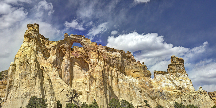
Another location that is often missed is the Wahweap Toadstools. You get there just north of Church Wells at Milepost 18. This is the Cottonwoods Canyon Road. It’s dirt and shouldn’t be attempted if wet or rain is in the forecast. Access to Wahweap is via an administration road that that turns right 2.25 kilometers off #89. From here on is 4X4 territory. We drove 17.2 kilometers through several gates (the last two should be closed), terminating at a wash after the last gate. We parked and walked downstream roughly three quarters of a mile to the site. It’s a sunrise to morning location and well worth the effort if you can find it. We got there a bit late and cursed the lack of defining shadow structure. There are three “coves” housing the hoodoos or toadstools. The first is spectacular, the second good but the third needs some mothers love from a photography perspective. The walk is exhausting on a hot day so take plenty of water. Continuing along the Cottonwood Canyon Road we travelled through the colorful Coxcomb formations but left Grosvenor Arch and Kodachrome Basin State Park for later in the trip when we were closer to the north end of the road.
The Coral Pink Sand Dunes State Park, described as a shifting sea of red sand, was a total disappointment from a photography perspective. It’s an area dedicated to OHV enthusiasts. Walking is out of the question unless your legs can stand hours grinding through what can only be described as stiff porridge. There are definite landscape opportunities but they require an OHV to gain access. We opted for an afternoon at Zion National Park where we focused on “grabs” of rock formations along the Mount Carmel Highway and vistas of the East Temple as we neared Canyon Junction. Roadside access is tight along this stretch and requires a quick drive to ferret out the locations that exhibit potential. We didn’t have time to take the shuttle along the Canyon Scenic Drive but opted instead for a hike up the Overlook Trail, again hoping for a sunset opportunity. It’s more of a sunrise location and is problematic as traffic is constantly moving on the switchbacks creating trails of headlights as the evening light dims. If you have time, work the area, as it exhibits a steep and varied stratigraphy that layers a revealing and seldom seen geologic diversity.
The real gem of this area is Bryce Canyon National Park. Plan some time here as the locations are not only photography friendly but also riddled with opportunities that range from grand vista to intimate. Although there are no sunrise or sunset opportunities, the park has definite morning and afternoon locations. It is a north-south area where the sun traverses the major overlooks and trail viewpoints, forcing photographers to choose their vantage points, not only seasonally but also by time of day. The Amphitheatre Region, with the exception of Sunrise Point, houses four exceptional locations, Sunset Point (including Thors Hammer), Inspiration Point (including Wall Street and the Navajo Loop), Bryce Point (including the Grottos and Arch) and a short side road to the Paria View. All are good morning and afternoon locations where you position given the prevailing light. The south end houses the Natural Bridge, a definite gem and afternoon location. It’s worth stopping from Swamp Canyon to Yovimpa Point, especially at the controlled burn sites, where seasonal flowers make a striking contrast to the forest renewal.
It’s a good idea to take a break from Bryce at some point. We choose the north end of Cottonwood Canyon Road just outside Cannonville to 4X4 our way to the Grosvenor Arch. This is a wonderful location if you can reach it, best caught in afternoon light. We were accosted by a very compliant Scrub Jay who posed on the sagebrush in the parking lot, obviously mooching for scraps. Utah has the best clouds we have ever encountered and hopefully you will be similarly blessed if you decide to do a canyon or desert tour. We then back tracked and scouted Kodachrome Basin State Park. We decided to return the next day and walk the Angel’s Palace Trail, a 2.4 kilometer walk that boasts photographer friendly vistas. This is definitely an early morning to late afternoon location and worth exploring. Another good afternoon site is the waterfall on the walk to Mossy Caves. It’s a bit difficult getting down, but worth the effort if you remember to use a polarizer to create that silky look as the water cascades to the pond below.
From here we entered the final two parks at the tip of the San Rafael Swell. The first is Capitol Reef National Park, a roughly ninety mile moncline or wrinkle in the earths crust that preserves an eroded tangle of cliffs, monoliths, arches and canyons in the Waterpocket Fold. This is “red rock” country, stunning and vibrant. During the morning, the locations we visited were readily accessible but fairly remote, Factory Butte at sunrise then on to the Hickman Natural Bridge. As the day progressed, we worked some colorful and abstract bentonite mounds in the late afternoon and evening light. These are bypassed by most photographers but make for excellent fare as the striped grays and reds are stacked in a striking contrast to the deep blue sky, best captured with shadows from defining side light. The next morning we decided to frame the abandoned farm machinery that sits roadside near the Visitors Center. The golden glow of sunrise on the cliffs makes an excellent backdrop and counterpoint. It’s best to look around here as there are many old wagons that are hidden along Sulphur Creek, especially as you drive past the Visitors Center and look for sites to the left of the road. As the morning progressed, we let the light lead us through Twin Rocks, Chimney Rock and the Flauted Wall. In the late afternoon there was a solar eclipse but clouds managed to hide most of the corona.

Our evening ended at Sunset Point where we worked the glow using trees and rocks as anchors to our images. It’s a great location and an easy walk. Our last morning here was devoted to the ten mile scenic loop that starts just east of the Visitors Center photographing the abstract formations along the Capitol Gorge Road.
Our final destination was Goblin Valley State Park. For the most part it’s a morning location, with the exception being the evening and sunset glow that lights up the Three Sisters. At sunrise we suggest you try and capture the majesty of Wild Horse Butte just before the entrance to the park. There is a short dirt side road to the right where you may find either blooming flowers or sage to act as foreground objects. It’s now time to change gears and get up close and personal with the many “mushroom” like forms that give the park its name. Take the first left past the entrance and look for objects on the right along the way to the Observation Lookout. We spent a few hours in Valley One walking amongst the “goblins” looking for intimate ways to frame either individuals or groups with the interesting striations that make up the desert floor. If you’re blessed with a cloudy sky, this is a location that you won’t want to miss. It’s an extremely hot area, so take plenty of water. In the late morning we took a 4X4 plunge into the desert to Molly’s Palace. This is a vista location that sports a great look at the back side of the park.
You could literally spend a life time photographing the Grand Canyon. The depth of the gorge, layered geology and ever changing weather patterns will simply overwhelm your senses. Dedicated landscape photographers are continually challenged with “timing” this location to capture the images they envision. We decided to focus on the south rim in late January of 2017 with the hope that a fresh snowfall would add an element of character to the locations we planned to visit. Our objective was to take advantage of early morning and late evening light and deal with whatever the weather threw at us midday. Fortunately our arrival coincided with the tail-end of one of the worst storms the area had experienced in years. This made driving conditions and foot access to the viewpoints somewhat hazardous as the snow was deep and the temperatures well below zero. Most viewpoints required crampons as the foot paths were well packed with hidden patches of solid ice. However, the pristine snow coating the south rim created a dramatic winter atmosphere that left us breathless. The early morning and late evening light created a glow on the rim with the opportunity to capture the blues and reds cast by the “earth’s shadow.” Our favorite morning and evening locations were Mojave and Lipan Points respectively. On several days the clear skies made photography difficult without clouds to add some character and depth to compositions. However, other opportunities abound with panoramas, icicle formations and telephoto close-ups of canyon geology where shadows help define the curves and diagonals above the Colorado River. It’s a must location that certainly demands many return visits. A good bet is late August during the “monsoon” season when summer storms bring lightening to the canyon, creating new and exciting opportunities.
As a side note, we revisited the slot canyons near Page on our way home. What a disappointment. The caverns had certainly deteriorated from their former pristine condition. Many rock edges were broken and the vertical surfaces streaked with water marks and eroding sand. The ledges were also littered with dirt and bird guano, making it virtually impossible to hone in on decent compositions that are typical of the well published canyon abstracts. In our opinion, both the Upper and Lower Antelope Canyon locations are well beyond their prime as time and the incredible volume of tourists crammed through their narrow paths has taken its toll. We would recommend a miss but if you pathologically feel the need to photograph the caverns, prepare for a tough outing.
After our winter experience in January photographing the South Rim of the Grand Canyon, we were looking forward to visiting again during the middle of August when the annual monsoon season brings intermittent but intense summer storms that carry with them the potential for thunder and lightning. This is also peak tourist season and much of the south rim can only be accessed by the park transit system. As the eastern auto-route was open, we decided to concentrate on the morning and evening locations that predictably cough up great sunrise and sunset landscapes. We weren’t disappointed as fluffy cumulonimbus clouds created incredible red skies. However, other than a single afternoon downpour, the expected monsoon weather had taken a hiatus leaving us mildly disappointed but enjoying familiar locations such as Lipan, Moran and Navajo Points. The highlight was sunrise at Yaki Point, a location we hadn’t previously visited.
Although the South Rim vistas are stunning and easily accessible, in our opinion the North Rim locations are much more intimate, bringing you closer to canyon icons such as the Vishnu Temple which can only be placed as distant but visible objects in photographs captured in locations such as Duck on a Rock. At this time of year, there are predictable sunrise and sunset locations that won’t disappoint. Although the road to Cape Royal is a narrow and winding nightmare to drive, the vistas surrounding the Vishnu Temple and Wotan’s Throne can produce great compositions bathed in sweet evening light. We had a similar late afternoon experience at the Wahalla Overlook. An incredible morning location is Imperial Point where the sun lights up Mount Hayden and casts shadows throughout the surrounding landscape. Eliminating the sky from compositions creates a “layered” effect as the hills cascade into the distance. The Angel’s Window on the Cape Royal route is another good morning site as the sun can produce a visible beam through the rock opening. There are two good spots to capture this effect but the upper location is dangerous as there is no railing. It’s a site that should be scouted in daylight and requires a headlamp for predawn setup. We did make an afternoon visit to Greenland Lake where the historic Bar Z Ranch salt cabin is still standing. It’s not an especially photogenic structure as positioning for compositions is difficult given the trees that have been removed as a precaution against fire destroying the structure. In our opinion, it’s a definite miss.
We plan to return to the canyon as “monsoon” photography is an attraction we still want to experience. There are also birds and wildlife in the area that we’d love to photograph, especially the tassel-eared Abert’s and Kaibab Squirrels that are prevalent on the South and North Rim’s respectively. We had no trouble locating then but were surprised to learn that their tufted ears are a winter phenomenon that would have to await a later visit.
We also scouted locations for Saguaro cactus in the Phoenix area and found some awesome sites near Fountain Hills at McDowell Mountain Regional Park that would make great sunrise and sunset images. We took a few daylight documentary images and posted them in the above Gallery. You can see how we fared in Galleries 101 and 104.