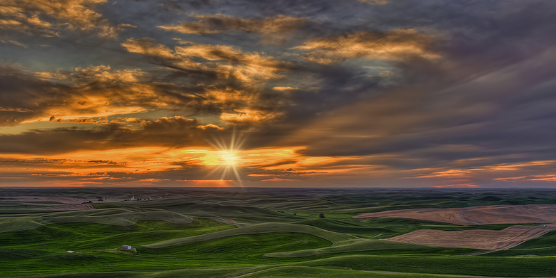
The Palouse is a spectacular agricultural area in north eastern Washington near the Idaho border. It is best known for its "loess" hills. These fertile and vast rolling fields produce winter wheat and specialty crops such as lentils, peas and barley, housing some of the most productive dry land contour farms in North America. The centerpiece is Steptoe Butte where outstanding roadside vantage points provide a three hundred and sixty degree panorama of the surrounding undulating fields. Here early morning and late evening side light creates lingering shadows that accentuate and define the divergent and colorful crops. Sunrise and sunset are must events, especially if character clouds are present. Access requires a Discover Pass as this is a Washington State Park.
The Palouse can be characterized as retaining an element of "old world" charm where pioneer buildings, barns, churches, grist mills, country schools, farmsteads, and abandoned machinery and vehicles still dot the landscape. However, finding interesting subjects can be a daunting task as its easy to get lost in the labyrinth of back country roads. Moreover, dust and private property often combine to make photography a difficult task. We tackled the area by researching the most notable attractions and plotted locations on a detailed roadmap of Whitman County. Our first blush netted us almost fifty "musts," most of which were not all that easy to pin down. Although the Palouse is well photographed, the websites we visited were less than forthcoming when it came to identifying specific locations and ease of public access. Fortunately, we came across a series of maps that segmented Whitman County into six areas detailing the road name and rough location of barns, lone trees, viewpoints, abandoned houses, granaries, windmills and abandoned machinery or vehicles that might be of interest to photographers. Marrying this guide with our map of "must" attractions left us with a detailed and manageable approach to photographing the Palouse. It was now a simple matter of visiting the small towns and driving the back roads to see how we could position to photograph the interesting subjects from the locations we had managed to isolate. We augmented our usual landscape lens selection (16-35mm and 24-105mm) with the more powerful zoom capability of a 70-200mm and 28-300mm to try and overcome the difficulty of finding interesting roadside subjects that were on private property and could only be framed using a longer lens. As it's within a days drive of our home, we decided to photograph crops and clouds in the middle of June and the harvest in late July and early August. You can view our most recent images as well as some perspectives from an earlier trip in Gallery 81. Its an unbelievable experience to photograph the Palouse. We're not sure anyone can do it justice. In our opinion, it ranks well within the confines of Yellowstone, the Grand Tetons and Yosemite as a North American photography destination.
Our base was the Best Western Wheatland Inn in Colfax. If you visit the area, we'd certainly recommend adding Palouse Falls State Park to the agenda. It's just south of Washtucna on Highway 26 roughly an hour from Colfax. Besides the falls, this is a great location to capture Yellow-Bellied Marmot as they enjoy the sun near the cliff edge. The fence posts and lichen covered rocks that line the last mile of roadside before the entrance are also an excellent place to find Horned Lark. This is an afternoon location as the falls face west and a definite place you need to watch for rattle snakes if you decide to hike to the canyon bottom.
If you are unfamiliar with the area and visiting for a first time, the following outlines specific directions for a five day driving tour that will pinpoint the best locations, hit all the highpoints and eliminate what we consider to be the least productive areas from a photography perspective. We've spent considerable time on the back roads and have distilled our experiences into what is hopefully a good overview of what the Palouse has to offer, at least in June and July. If you drive these routes, there is also the opportunity to photograph many churches, public buildings and the old town atmosphere that pervades many the small bergs you will pass through.
Consider starting at Steptoe Butte for sunrise. It's a short distance north of Colfax on Highway 23 and the entrance is a well marked right turn onto Hume Road.
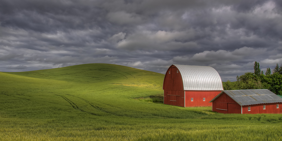
Return to the highway and continue north, turn right on Curtis Road then right on Cooke Road. Here you should encounter an old farm machine on the right. Turn left at the first dirt road (McCanso Road is not marked) and watch for viewpoints on the left (here we found yellow Canola that made a colourful foreground). You will eventually reach Elmer Huntley Road, turn left and continue until you see an old barn on the left. This is a morning location and needs some work to eliminate the telephone poles and wires from your composition. There is a junction at this point so turn right on Ingram Road then right again on Harry Davis Road until you reach a lone tree. This can be an interesting location whether the field is planted or lying fallow. Try compositions at both ends of the road. Continue on and turn right on Hitchings Road, watching for an old barn on the right. Turn left when you reach Sunset Road and watch for an abandoned house on the right. This is on private property and tough to photograph from the road but you may find some interesting perspectives using a longer lens. We encountered a cow moose and two calves here, a sight we definitely didn't associate with Palouse farmland! Continue on Sunset Road until you reach Jim Henning Road, turn left and look for an old barn on the right. At this point we returned to Sunset Road and followed it to Highway 23, taking a left into St. John for lunch. You'll see an old granary as you enter town. It's been renovated at one time with some metal siding that is now in disrepair but to us didn't make much of a subject and was difficult to compose. The key features just north and on the left of Highway 23 are the Erikson barn and the Steinke "twelve-sided" barn. You can't miss them and both make great subjects. As they are on private property, you will need permission from the owners if you plan to add them to your photography tour. As the day was getting on, we headed for Steptoe Butte hoping that the clouds and late afternoon sun would create sidelight shadows and a sunset to end our first day.
A good morning location is a barn on Parvin Road just south of Colfax (turn left on Parvin off Highway 195). We had fun here with a pair of inquisitive horses, hoping they would stand still while we tried to bracket multiple images to capture the dynamic range of light. We headed back and took the first unmarked road left until we reached Shawnee Road. Turn right and then left on Hoffman Road and watch for viewpoints until you reach Albion Road. We like this stretch of road as we encountered an interesting farm scene and a windmill which we tried to compose using the winter wheat as foreground. We were continually hampered by a light breeze and throughout our trip and had to wait at many locations for the movement to stop as bracketing was the only way we could capture the wide range of ambient light. Turn left on Albion Road and left again on Banner Road where you will find a maroon barn that makes a nice setting. Continue up Banner Road, turn right on Albion Road and take a left at the Tate Cut-Off. Here you will find another old barn. Watch for Great Horned Owls that usually roost in the loft. Continue on to Parvin Road, turn left then right on Abbot Road and left on Kenoyer Road. Here you will see a piece of abandoned farm equipment on the right that makes a good foreground object for the red barn and fields as you look down Kenoyer Road. Follow this road to South Palouse River Road, turn right and left again on Fulgate Road. This will take you to the Skeen School which still stands due to the good grace of an old truck chassis that is used to support one side. This location houses a lot of abandoned farm machinery and household effects that can be fun to photograph as you move around looking for interesting perspectives. Follow Fulgate Road to Clear Creek Road, turn left and continue until you reach a viewpoint. Then backtrack to Fulgate Road, take a left to Highway 27. Left will take you to Palouse and lunch. In the afternoon, travel north on Highway 27 and turn right on Lodow Butte Road watching for an old barn on the right just past Kriebel Road. That's pretty much it for this area. Continue on, turning left at Mark Hemmingway Road and travel south once you reach Highway 27, turning right onto Altergott Road. This will take you to Highway 272. Turn right and head toward Colfax. Again, we like to end the day in late afternoon by heading to Steptoe Butte. If it's still early, there are several barns on the way that might prove interesting. One is on Hilty Road (turn right off the highway) just before you reach Colfax. If you take this side trip, you'll need to backtrack to Highway 272. Otherwise continue on to Colfax and take the 195 north to the entrance at Hume Road. When you get to Schotz Road, turn left and look for old machinery, a barn and a windmill at various places along this road. Turn right on Shahan Road for the last barn. To return to Hume and the approach to Steptoe Butte, continue on, turning right on Hall Road and right again on Merrell Road. An interesting location roughly 20 minutes after sunset is the foot of Steptoe Butte just after you turn right onto Hume Road. If a good cloud structure is present, the sky can illuminate the hillside and create quite a spectacular look.
Travel south on Highway 195 and turn left at Armstrong Road. Watch for a small barn to the left through an opening in the trees. Continue on and turn right on Brayton Road. Here you will pass a creatively landscaped property known as River Farm. It's golf club fence makes for an interesting perspective. You'll eventually pass old farm machinery on the right where the old barn makes a good backdrop to the abandoned tractor. Watch for an old truck roadside when you get to the granary. Plan to spend some time on this stretch of road as it can be a lot of fun with the morning sun at your back. You'll now need to backtrack to the 195 and continue south, turning right onto the 194. This will eventually take you to Almota and the Lower Granite Dam. First though, turn right on Hamilton Road and look for the remnants of what appears to be an old suspension bridge on the left. Return to the 194, turn right then left on Benedict Road and work your way through three barns, including the historic 1877 Mays barn, until you reach Jenkins Road. Turn left on Severs Road. This stretch has many viewpoints. Turn right at Long Hollow Road and look for a red barn on the left just before you reach Steiger Road. Continue on Long Hollow Road, turn right on Spaulding Road and return to Highway 194. Travel south and look for panorama opportunities roadside as you descend into Almota. There is a good place for lunch at the marina.
Heading north from Almota on Highway 194, turn right on Kamerrrer Road and look for a bone yard of abandoned farm machinery on the left. This can be a challenging location to find interesting perspectives but worth the stop. Continue to Ewartsville Road, turn right then left on Klemgard Road until you reach the Wawawa-Pullman Road. Turn right and continue on to Hatley Road. Turn left and left again at Barbee Road, watching for an old barn on the left. This will take you to Witboum Road and a right will get you to Highway 195. Head south and look for an old granary on the left between Kirkendahl and Gemlin Roads. At this point we would suggest ending the day with a visit to the wheel and gear fence at the old Dahmen Barn just south of Uniontown.
Travel north on Highway 195, turning right at Rogan Road, then right again at 2220 looking for machinery or vehicle on the left. Continue to Moore Road, turn left and look for an abandoned house on the left. This road leads to Hume Road. Turn left then right on JW Baylor Road and right again at the first road you reach (should be 2360). Look for a viewpoint. Continue on until you see a barn on the right. Backtrack to JW Baylor Road, turn right and look for a lone tree on the left. Continue past Hubner Road, turn left and continue past South Ptaff and Crabtree Roads, turning left on Higgins Road (2320 is a good morning location for rolling hills). Here you should find three viewpoints as you drive toward Peringer Road. At the junction, there is a granary on the right and some machinery on the left. Continue on Huggins Road, cross Hume Road onto FR Martin Road and look for a barn on the left. Continue past Balthis Road, turning left on Tibbett Road until you reach a windmill on the left. Continue on until you reach Bernard Road, turn right and look for machinery on the right just before you get to Ripley Road. Turn right, left on Oakesdale Road and left on Greer Road looking for an abandoned house on the left near Renner Road. Take Renner Road until it dead ends at a viewpoint. Back track to Oakesdale Road, turn left and look for three barns on the left near Kilpatrick Road. Turn right on here and continue until you reach a viewpoint on the right. Turn right at Finch Road and right again at Trestle Creek Road where you will find an old barn on the right just before Rambo Road (which dead ends at a viewpoint). Back track to Trestle Creek Road, turn left then right at Eckhart Road. Look for an abandoned house on the right. Back track to Crow Road, turn right and again look for an abandoned house on the right.
Depending on the time, you can either visit Oakesdale (Barron Flour Mill and Handford Castle) or complete a route through the Farmington area. We chose the latter, opting for a late lunch. Take Highway 27 south, turn left at Kelly Road and look for an abandoned house on the right. Return to Highway 27, turn left. Just past Black Road look for the abandoned Belmont house on the left and a barn and granary on the right (the barn might be to the right on Peringer Road). Continue down Highway 27, turning left at Waters Road looking for a viewpoint then an abandoned house just to the left near Walter Siding Road. Continue on Waters Road, turning left on Faught Road looking for a barn on the left and an eventual viewpoint. Turn right on the Garfield-Farmington Road where you should see first a barn (on the left) then an abandoned house (on the right). Turn around and again look for a barn (on the right), a barn (on the left) and finally a granary (on the right) just as you reach Farmington. Take Farmington back to Highway 27 and look for machinery on the right just after you pass Hollingsworth Road. There is also a barn to the left but it could be easier to photograph from Miller Road.
Take Highway 27 north to Oakesdale. Turn right on Balthis Road and see a granary on the right. Continue on to a second granary near the Warner junction just to the left on Fanning Road. Continue on Fanning Road looking for an abandoned house to the left just after Sienknect Road and a barn on the right just a short distance ahead. Turn right on Tom Norton Road then left on Bancroft Road where there is a viewpoint. Turn around and continue along Bancroft until you see some machinery on the right. Turn right on Hanson Road then right on Sienknect Road looking for a viewpoint. Turn right on Fanning Road and look for a viewpoint just before you reach Highway 27. Turn left here and right at Miles Road. Turn right at Pittman Road and look for a viewpoint, then a lone tree, both to the right. Turn left on Fox Road, looking for a barn on the right. Turn right on Engel Road and left on Seaberry Road where there is a granary and some machinery to the left near Fairbanks Road. Turn left onto Engel Road, right on Bongarts Road and right again at Withelm Road looking for a barn on the right. Turn left on St. John Road looking for machinery and two barns in three separate locations, all to the left. Turn right on LH Johnson Road and left on Hughes Road where you will see a barn on the left.
Here you can decide on how to end the day given weather conditions and stamina.
If you want a day with less locations then this is a good choice. Travel Highway 26 west from Colfax until you reach Endicott Road. Turn right and look for machinery on the right. Turn left on McNeilly Road and right on Bumgamer Road looking for a barn on the left. Turn left when you reach Endicott Road and travel through Diamond looking for a barn on the right before you reach Huntley road. Turn left here and look for two barns, the first on the left and the second on the right. Turn right on McNeilly Road and left on Union Flat Creek Road where you should see a barn on the right just before reaching Highway 26. Follow the highway west and turn right on the Repp-Steiger Road looking for machinery on the left. Turn left on the Union Flat Creek Road and right on Ed Hamilton Road until you reach Repp Road. Turn left and look for two viewpoints. Turn right on Keiser Road and look for the viewpoint just as you reach Ed Hamilton Road. Turn left and look for machinery to the right and an abandoned house to the left. Turn left on Endicott Road and have an early break at Endicott.
From town take the Endicott-St John Road looking first for a barn and windmill on the left and a red barn on the right, all near Lee Road. Continue past Lee Road and a road to the left, taking the next right where there is machinery to the left. Continue on to a barn on the left and a viewpoint just before Delong Road. Turn right and look for a barn on the right just before the road dead ends. Return, turning right and travel to Highway 23. Turn right and look for an abandoned house on the left just before Jack Lloyd Road. Turn left and continue until you reach a lone tree. Back track to Highway 23, cross to Green Hollow Road and turn right on McGrady Road looking first for a lone tree and then a barn, both on the right. Turn left on Shields Road and look for a windmill on the left just past Frank Feenan Road. Turn left on Gene Feenan Road, looking for a barn on the left and a viewpoint just before reaching Manning Road. Follow Manning Road until you see some machinery on the right. You are now near the Covered Bridge which can be reached by turning left on the next gravel road. This is an afternoon or early evening location. You now need to decide how best to complete the late afternoon and evening.
As you progress through each route, be conscious of compositions that may lend themselves to a black and white format. Barns and abandoned machinery and cars are good subjects. There are presets in packages from Nik Software such as Silver Efex Pro 2 that are quite appealing and reduce your workflow considerably. We like the Quadtone look that is build into Photoshop 6. Try the following:
Step 1: D
Step 2: Image>Adjustments>Gradient Map
Step 3: Image>Mode> Grayscale>Discard
Step 4: Image>Mode>8-Bit
Step5: Image>Mode>Duotone
The final step is to pick a suitable preset from the drop down menu. We like "CMYK Very Cool" as a good Quadtone effect.
Rather than begin or end the day at Steptoe Butte, there are several alternatives that are just as exciting. One is a very early morning visit to the Dahmen Barn "wheel and gear fence" south of Uniontown. Two late afternoon or early evening locations are the granary between Kirkendahl and Gimlin Roads just off Highway 195 (late afternoon) and the salt barn and rolling hills five miles south of Moscow (one hour before sunset), left on Eid Road off Highway 95.