Refer to our synopsis on the Canadian Rockies for winter photography. The locations we suggest here are best tackled in either the summer (late July and early August) or fall (late September and early October). Spring days, roughly defined as those in May and June, are predominately wet and overcast with the forests and scrub filled with annoying wood ticks. It’s best to plan two trips to take advantage of the summer flowers and fall colors.
Again, Banff is a good area to begin as you now have access to locations that were unavailable during the winter months. A good beginning to a day outing is along the Lake Minnewanka Scenic Drive. As you’re likely to come across Bighorn Sheep along this route, it’s best to expect delays as not only the sheep but also automobiles and people can clog the highway. Our advice is to move on as any meaningful photography is impossible. There are much better and more photogenic alternatives for this and other species along the Icefields Parkway.
A mainstay of this route is Cascade Meadows, good sunrise to mid-morning and evening to sunset. Here you are almost assured that the open meadow will be punctuated with ox-eyed daisies and perhaps the odd Elk, making a colorful and dramatic foreground to Mounts Rundle and Inglismaldie. You’ll need to make a location decision here as sites at Johnson Lake and Two Jacks Lake offer similar sunrise to mid-morning opportunities. Johnson Lake is a good choice as it is sheltered and usually placid. Try either below the parking lot to frame the Fairholme Range or walk roughly one and a half kilometers to the end of the lake to capture Cascade Mountain. You also have two choices at Two Jacks, either by boat across from the campground to frame Cascade Mountain or at the picnic site for a good look at Mount Rundle. A good plan is to scout all the above locations and plan a couple of early mornings to capture your favorite vistas. There are few compelling locations from here to Lake Minnewanka and the dam. If time strapped, we recommend moving on as there are two interesting locations just minutes up the road.
The Upper Bankhead can be reached from a small side road to the right that leads to an old coal mining town. Here you may be interested in walking the four kilometer C-Level Cirque trail to a rock pile housing Pika and Hoary Marmots. This latter species is difficult to find at the best of times without straining your legs so here is an opportunity to cross them off your list (there is an alternate location on the Icefields Parkway in the Sunwapta Pass that may prove a better choice as the walk also encompasses vistas that include Bighorn Sheep). A little down the road is the Lower Bankhead. This is a must stop if you are looking for something more than just scenery. Here an abandoned anthracite operation offers lines of disintegrating coal carts and old pilings that make interesting foreground objects to frame the distant mountains. There are also many meandering streams where you can focus on water blur images in meadows strewn with wild flowers that frame majestic views.
There are also good locations within the town of Banff to either begin or cap-off a day. Although vistas of Mount Rundle and the Bow Valley can be gleaned sunrise to mid-morning from several locations along Tunnel Mountain Road, we feel it is best at the Hoodoos in late afternoon from the third platform along the walkway. A must is Cascade Gardens, either mid-morning or evening. It’s just over the bridge at the south end of Banff Avenue. This is a sculptured rock garden with mountain views where flowers make a good foreground in spring and summer. Alternatively, late afternoon to sunset can produce stunning images at the meadow, known as the “green spot,” on the Mount Norquay Scenic Drive. Use the rock wall at the parking lot as a foreground to Mount Rundle and the Goat Range. This is also a good location for Bighorn Sheep in the summer and fall. To us, Vermillion Lakes is a winter location, but many photographers love the late evening light along this route at this time of year, especially if the west face of Mount Rundle is encapsulated in any kind of dramatic cloud structure.
We feel the Bow Valley Parkway can be disappointing. There are better locations in Jasper if you are looking for abstracts of, say, aspen groves or moving water. As such, we generally bypass the opportunities offered at the Muleshoe or Johnson Canyon. There is a gem, however, sunrise to mid-morning just west of Hillsdale Meadows at Pilot Pond. Use a wide-angle lens to capture placid images of the lake framing the forest and Pilot Mountain. Although the bridge at Castle Junction is a must winter location, try it in early August as you may catch Osprey fledging from the nest on the center span. If you are a train buff and want that classic Rockies image framing the Bow Range, visit Morant’s Curve near the end of the road. It’s best mid-day for side light and can be a killer location for winter images.
No trip to the Banff area is complete without a stop at Moraine Lake. A side road to the left midway to the hotel at Lake Louise leads to a parking lot and short walk up the “rock pile” to what is the classic and much photographed view of the Wenkchemna Peaks. It is best mid-morning and requires a 17mm to 24mm wide angle minimum to gain the full vista. Shadows darkens much of the forest, lake and lower slopes, demanding a bracketed HDR approach to reveal enough detail to produce a good image. Watch for a haze produced by wind and forest fires as the summer progresses.
From here there are three hikes that can produce stunning images. The best, but most strenuous, is a three kilometer trek up the Larch Valley in the fall. An easier venue of similar length is the walk to Consolation Lakes along the Babel Creek trail. Here on the lower slope you will encounter moss and lichen boulders surrounding small pools that frame Mount Babel. Lastly, you can walk to the end of Moraine Lake to the inlet stream and capture water blur framing the forest and peaks as background. To us, if you have the stamina, it’s the Larch Valley all the way to the bank! Wait for a group as you may encounter bears.
This section is well covered in the winter synopsis. As such, the prime focus here is locations previously unattainable (included, however, are some familiar stretches of road that can house some interesting perspectives during this time of year). If you visit earlier than summer or fall, be cautious of bears during May and June munching greenery roadside. It’s best to move along if more than two or three cars have pulled over as bears are almost impossible to isolate even with a long lens if crowds begin to gather. Getting out simply disturbs their foraging.
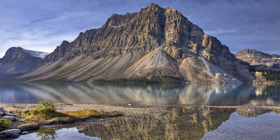
Herbert Lake is worth a stop if the water is calm, sunrise to mid-morning, for panorama images reflecting the Bow Range. Look for sunken logs at the south end of the lake in the clear shallows for use as foreground objects. Don’t linger if the conditions aren’t right. The real sunrise and early morning events are at Bow Lake and the Peyto Lake Summit. Both offer good sidelight, recommended sunrise to early morning. Focus first on water reflections of Crowfoot Mountain. A good location is the shoreline near the bridge at the Num-Ti-Jah Lodge. This also makes a good foreground object. Later, frame the mountain using fireweed along either side of the highway or from the lodge parking lot. The viewpoint at the Peyto Lake Summit is another Rockies icon, framing Calderon Peak and the Mistaya Valley. A must stop, best shot sunrise to mid-afternoon. Walk the bus road rather than the trail as fireweed is prevalent and can make good foreground. Often overlooked is the Observation Pond directly across from the highway entrance. You’ll need high rubber boots but a walk around usually results in a good frame of the pond, reeds and reflection of Observation Peak to the east. Try a panorama or widest angle possible. Now is a good time to back track about eight kilometers to the Bow Valley Outlet. This is another must stop but hard to locate. Watch for surveyors tape on the west side of the road that marks a one kilometer pathway to the river outlet of Bow Lake. This is a classic Rockies vista best shot in sidelight mid-morning. This can also be a good winter location if the snowfall is relatively light.
Progressing north from Peyto, another overlooked location is Silverhorn Creek. This is best shot evening to sunset. Look for a water blur framing Mount Weed. This is also a great place to end the day if you are staying at Lake Louise.
Start at Upper Waterfowl Lake the next day. The shoreline is a very short walk from the parking area. If the lake is calm, sunrise to mid-morning, try either a wide angle or panorama framing Mount Chephren using the rocky shallows, reeds or flowers as foreground. The campground a short distance down the road is a good place to watch for bears. The two or three roadside viewpoints of the Lower Waterfowl are best late morning but wind can be an annoyance. Look for the Oxbow as a surreal image is possible in early summer if high waters from the Mistaya River have flooded the inner channel. This is best sunrise to early morning as mist often frames Epaulette Mountain, the Kaufmann Peaks and Mount Chrephren.
Another must stop is Mistaya Canyon. One of the best slot-canyons in the Rockies, it is best photographed when overcast due to the wide tonal range produced by the deep crevices. Look for the Beaver pond about sixteen kilometers up the road. This is a hard to get species at the best of time. Here they are accustomed to human traffic and should be observable in the open either early morning or late evening. A scant two kilometers further on are several roadside access points to the Rampart Ponds. This is a good location anytime except mid-day but must be scouted for shallow ponds, submerged rocks or wildflowers that can anchor your images. Watch for bear and moose. From here on the wide alluvial gravel channels and beds along the North Saskatchewan River can also be walked to isolate interesting locations. Again, look for ponds or wildflowers that can frame Mount Avery.
You are now close to what can be best described as “waterfall alley.” Before you get too excited about the eight waterfalls and six canyons that dominate this area, two are steep and can be dangerous (Panther and Nigel Falls) and one will likely be dry in the summer and fall (Weeping Wall). If this is your first blush and time is a factor, we recommend the “wimps” tour, focusing on Coleman Creek and the Nigel Pass Trailhead. These are safe and take relatively little time. If you want a good location to explore, take the road on the left side of the highway that leads to the first of three small bridges. Here you will encounter a deep limestone crevasse. Look for interesting compositions from here to the third bridge at Nigel Creek (watch for the old abandoned car wreck as you approach). Nigel Falls is a short walk upstream.
Once you reach the Columbia Icefield you are roughly at the midpoint of the Icefields Parkway and entering Jasper National Park. From here on we tackle our recommended locations from a base in Jasper. To begin, we generally cruise the highway looking for compelling images from Sunwapta Pass to the Stutfield Glacier Viewpoint. Exploring this area takes time and requires several visits to locate and photograph the surroundings to good advantage. We strongly recommend the Wilcox Pass Trail, especially the first four kilometers during the fall. The high alpine meadows house flowers, berry bushes and dwarf trees which make a wonderful foreground to Mount Athabaska, Andromeda and the Snow Dome. It’s a great area for Bighorn Sheep (the rut begins late October), Mountain Goat, Hoary Marmot, White-Tailed Ptarmigan, Pika and both species of Ground Squirrel. You’ll need both a wide angle and telephoto lens.
There are two good locations just up the road. If you visit Tangle Falls, be sure to try the footpaths to garner more intimate images of the falls and layered limestone formations. There is a trail and short walk at Beauty Creek that leads past eight waterfalls, culminating at the picturesque Stanley Falls. As you progress a short distance north, watch for a large reflecting pool jammed between the highway and the Sunwapta River. It’s an iconic shot! From the campground at Honeymoon Lake, you can glean a good eastern view of the Endless Chain Ridge, mid-day to sunset. Watch for moose.
As in winter, try roadside access to the Athabaska River sunrise to mid-morning to frame images of Mount Christie, Brussels Peak, Mount Fryatt and Whirlpool Peak. Again, watch for Mountain Goat near the Kerkeslin rest stop. Be sure to check the hoodoos behind the ridge as they frequently relax on them in the early afternoon. This latter location is also a good place for a panorama overlooking the valley. As this is close to Jasper, plan to end the day at Athabaska Falls, mid-afternoon to sunset or anytime that it is overcast.
A hidden treasure is Horseshoe Lake. It’s deep metallic blue water, thin pine forest and colorful slanted rocks all offer great opportunities for abstract images, including reflections. Try the north end during the evening to frame Mount Kerkeslin. Finally, the Whirlpool Valley Viewpoint can be a tremendous panorama location. We use the top of our trailer or the canopy on our truck to gain a better perspective.
Summer and fall offer significantly more access to this area than the winter months. As with our initiation to Banff, we’re looking for comfortable photography that hits the highlights until we get a better feel for the area. As such, we’ve again chosen late July to early August and late September to early October to avoid the rain and wood ticks prevalent during the earlier months. An exception you may find exciting is early June when bears are prevalent along the Marmot Basin Road. Notwithstanding, the 93A artery is a good route to start any visit at this time of year.
Cavell Pond, which is roughly thirty minutes south of the town site, is also a morning site but requires a short walk on a well established and maintained path. Here the attraction is Angel Glacier, a small waterfall and picturesque pond with floating ice. Mount Edith Cavell is, of course, a definite icon of the Canadian Rockies. Getting close is another matter! The access road off 93A is steep with switchbacks and a bit of a nerve racking drive but worth the effort. You’ll find two good viewpoints of the Astoria River Gorge and headwaters up the road roughly four and twelve kilometers respectfully from the junction. It’s a short hop from this last stop to the Astoria River and the Tonquin Valley trailhead. From the parking lot, it’s a short walk to the shoreline of Cavell Lake and a footbridge. Plan some time for this location. It’s good anytime except mid-day. If you continue on to the end of the road, the Path of the Glacier Trail can be rewarding if you take the short and less strenuous lower loop where flowers make a great foreground to the mountain scenery.
Upon returning to the junction, try several access points to the Athabaska River, framing either Mount Kerkeslin or Hardisty. This is best late afternoon to sunset and later in the year when the low water exposes more shoreline. Otto’s Cache and Meeting of the Waters are good locations to start. Alternatively, you can try the Moab Lake Road. This is an isolated gravel road but good late afternoon to sunset. There is a viewpoint roughly four kilometers up the road that frames Mount Hardisty using the Whirlpool River as a foreground. At the lake, walk the shoreline path past the boat dock looking for a strong scenic point. As you return to 93A and continue south, stop at the bridge for sunrise or sunset images of Whirlpool Peak.
There is so much to photograph in this area that you may want to devote several days to explore and plan your time. There are locations between Moab and Athabaska falls that are definitely worth exploring. Leach Lake is worth a try, especially from the north end where you’ll find good opportunities for reflections of Whirlpool Peak and Mount Fryatt if the water is calm. Down the road you’ll encounter the three small Fryatt Ponds, again reflecting Whirlpool Peak and Mount Fryatt to the east and Mount Kerkeslin to the west. Note that the third pond, roughly two kilometers beyond the first two, is a dangerous location as the meadows and foreshore are really a deep, spongy quagmire that require not only knee high boots but also slow, cautionary steps as they may swallow you alive!
Unlike the town of Banff, we feel the Jasper environs offers little in the way of compelling photography. There are two exceptions. The Tramway can be a worthwhile experience if the cloud structure dictates the possibility of an exceptional sunset. The other is the Pyramid Lake Road. This gem leads to some great locations (access is off the Connaught Drive main drag). Patricia Lake and Pyramid Lake are best sunrise to mid-morning for reflections of Pyramid Mountain, especially in the fall as the aspen groves change color (wind can often reek havoc so have patience as several visits may be necessary to capture a good image). There is always the potential to play with abstracts of the aspen grove at the picnic area. Pyramid Island is a good walk-around just over the small connecting bridge for views of the Trident Range. Best, however, is the outlet stream just past the parking lot at roads end. A short walk takes you to a sheltered bay where a reflection of Pyramid Mountain is are much easier to attain than along the earlier roadside locations.
As you leave town travelling west on Highway 16, give the Maligne Lake Road a quick peak. Although we consider this a winter must, it can cough up some good images during the summer and fall months. This is especially true of Medicine Lake. Many good spots can be found just down the wooden stairs from the parking lot. Here you can use the boulders and shallow shoreline as foreground to frame views of the Queen Elizabeth and Maligne Ranges. Watch for Pika and Short-Tailed Weasel scampering around the rocks that dominate the hill at roadside. In our opinion, the much vaunted Malign Lake, which is a little farther down the road, is worth missing at least from a photography perspective. The cost of the boat trip to Spirit Island is simply extortion, $55.00 CDN per person. It’s a forty five minute trip both ways and you are given a scant ten minutes timed to the last second to take in the dynamics of this setting. We’ve seen herded cattle receive better treatment! There was little interest in our request to take a later boat back.
In summer and fall it’s best to revisit the winter locations along Highway 16 in the mornings and evenings. A must stop sunrise to mid-morning is the Athabaska River bridge for a great look at the De Smet Range (Gargoyle, Esplanade and Chetamon Mountains). Lastly, a drive along the Miette Hot Springs road, although narrow and tree lined, offers interesting opportunities at the Collieries, Punchbowl Falls, Ashlar Ridge and the hot springs themselves at road end, especially Sulphur Creek. Watch for Bighorn Sheep at the parking lot.
As you leave Banff and head towards Waterton, the Kananaskis Country houses many good locations and can be a veritable treasure when the weather changes rapidly. The Mount Lorette Ponds in late morning produces wonderful reflections and is crystal clear with great potential for combining interesting foreground objects with mountain backdrops. Wedge Pond is an early morning site where alpenglow, mist and Mount Kidd reflections are all possibilities. Peter Lougheed Provincial Park houses two good late morning locations. The first is Panorama Point overlooking Lower Kananaskis Lake and the second is the left trail from the parking lot of Upper Kananaskis Lake. If the latter location is calm, the trail walk should cough up some good reflections of Hawke Island and similar potential as you reach the lower access points to the shoreline. Again, if the weather is sunny and calm, a spectacular afternoon site is the reflection of Mount Kidd from the Galatea Beaver Pond. You can't miss this from the main highway. Finally, if you want to try waterfalls, Cat Creek, although not large and a long walk, is an interesting stop. Photographers at this site told us Troll Falls is a better location, especially in early Spring and Winter when snow is still prevalent.
The last stop on this journey is Waterton Lakes National Park. Your best bet here is the rock and water formations at Red Rock Canyon, especially above and below the bridge at the parking lot. Cameron Lake, overlooking MacDonald Mountain, can be good if the weather cooperates, especially from the rocks at the bridge to the left of the visitor center. Both locations are not dependant on time of day. The drive between Kananaskis and Waterton is typical Alberta foothills farming country so be on the lookout for old machinery, buckboards, fresh hay bails, dilapidated houses and barns. All make for great fare if public access is available.
You can view the results of our first trip (mixed with natural landscapes from other locations) in Gallery 49.