Ever wonder where all those majestic images of the Canadian Rockies were taken? Pinpointing most of the iconic locations is relatively easy. However, being there at the right time and honing in with a stunning composition is another matter. It’s pointless to reiterate all the superlatives describing the vastness and grandeur of this area. To us, the Rockies are aptly named. It is, indeed, a large pile of rocks interlaced with streams, rivers, lakes and forests that house an abundance of wildlife that create an endless photography experience. Amazingly it’s also still relatively pristine. Despite the considerable infrastructure developed to handle the tourists and traffic that dominate activity during the summer months, it retains an almost surreal atmosphere from even the most easily accessible locations.
Seasonally, the Rockies can be characterized as having long winters with a short, wet spring and colorful, dry fall. If you’re looking for comfortable yet productive photography, there are definite times to avoid. June is wet and January bitterly cold. If you’re new to the area, we recommend the following times: WINTER - (December 1-15, February 21-28 and, March 1-7); SUMMER - (July 24-31 and August 1-7); and, FALL - (September 24-30 and October 1-7).
To begin, we define the Canadian Rockies loosely as encompassing five distinct but interconnected areas: Banff National Park, Jasper National Park, Kananaskis Country, Waterton National Park and Yoho National Park. This synopsis will focus on the first two, with the emphasis on visiting during the three seasonal recommendations above. We’ve isolated locations that are safe and readily accessible, either roadside or a short walk from your vehicle. The narrative is skewed toward landscapes but includes birds and wildlife that frequent specific areas. Don’t worry that you’re missing something in the backcountry. It will take several years and many visits just to photograph the easy stuff. Off road locations that require overnight camping are usually a tough slog. At our age, these lung-burners are definitely not our cup of tea! If you want an exhaustive list of the definitive locations, including specific mileages that pinpoint exact locations with seasonal and time of day recommendations, visit Darwin Wigget’s website on "How To Photograph The Canadian Rockies". It’s absolutely the best overview of landscape and wildlife photography opportunities in the Banff and Jasper areas. Our synopsis is a little more pedestrian, keying on the more accessible sites that are a mainstay of Rockies photography. All are accessible roadside and easily fulfill what for the most of us are short visits with hopeful expectations.
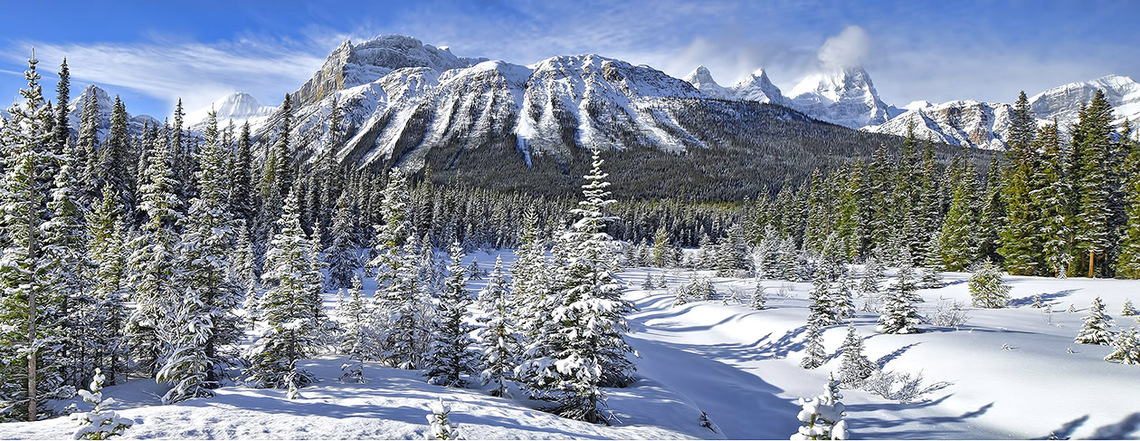
Our objective was to begin to produce an anthology of photographs depicting specific locations in the Canadian Rockies from a seasonal perspective. What better place to start than winter as we felt the contrast from the summer months was at least a gauge from what we experienced during the high traffic tourist season. Notwithstanding, from what we had read, including the above definitive Rockies photography recommendations, nothing prepared us for the actual winter experience, especially as it applied to the conditions we found in October and the early part of December. During the former period, we found only a dusting of snow to contrast the open water creeks we hoped to photograph. We caught the odd wildlife roadside but nothing really grabbed our attention despite the miles we put in. Early December was another matter. Deep snow covered most of the popular locations and much of the open water that remained was clogged with ice jams. Snowplows created high roadside snow banks and at one location, the Quartzite Boulder Pile on the Icefield Parkway, splattered snow over what could have been an excellent opportunity to capture some abstract images. To our surprise, the Bow Valley Parkway to Lake Louise was clear. Baker’s Creek was completely snow bound and a bust but Morant’s Corner provided vistas mid-morning that took your breath away. If we had one recommendation to travelling through this area as December progressed it would be to carry a light pair of snowshoes as the off road potential to capture good sidelight with foreground objects is limitless. This also applies for the Icefields Parkway and the Jasper winter routes.
This is a relatively small area to cover in winter but requires time (a recurring theme throughout this synopsis). We have identified certain must stops such as the Castle Junction Bridge but there are many other viewpoints that can produce stunning winter images given the right conditions. Winter sunrise and sunset occurs roughly at 8:45 AM and 4:30 PM respectively, although we found the productive time within this period to be relatively short. The one advantage to this time of year is that the sun is low angle, creating good shadow detail. Most locations are roadside or within a short walking distance from your vehicle. This makes for a convenient and comfortable driving visit, stopping for photography only if the right weather conditions prevail.
A good place to start is Cascade Ponds at sunrise. This is a local picnic area that can produce good winter scenes after a light snowfall if you can position to eliminate the odd building, bench and foot path. There are two bridges that make good foreground objects and can be striking as the early morning light casts shadows on the fresh snow. You can continue on the Minnewanka Scenic Drive and try the waters edge that connects Johnson and Two Jacks lakes. We generally bypass this area as the lakes are snowbound in early December and there are better morning locations elsewhere. The road is closed just past the marina with no winter access to the Bankhead area. It is, however, a phenomenal summer area as you will learn in a later synopsis.
A good early to mid-morning location is the Castle Mountain bridge just off Highway 1 midway to Lake Louise. This area is side-lit in winter at sunrise and front-lit at sunset, exposing castellated peaks. By early December the ice jams and snow leave little open water but what remains makes a good foreground for an image of Castle Mountain, especially looking upriver. Downstream provides eastern views of Sawback Ridge or the Massive Ranges. Access is from a chained gate that can be opened on either side of the road. As you drive to this location on Highway 1, look for similar gates along the highway where access can be gained to similar scenes with a much broader perspective of the Bow River. We use these often and have never encountered any signage restricting access. Remember, park well off the road and secure the gates when entering and leaving.
A good way to complete the morning is to cross the bridge, turning left at the gas station and lodge. You are now on the last leg of the Bow Valley Parkway. We found Baker Creek snowbound with no open water but it is a good location if winter is not too far advanced. As you progress down the road, watch for an opening on the left that provides a tremendous perspective of Temple Mountain, especially if a recent snowfall is still clinging to the tree line. The real vista for this time of day is Morant's Corner, so don’t doddle! It’s the classic iconic image of the Rockies railway if side light and cloud structure cooperate. You can’t miss it on the left as you descend a small hill near the access to Lake Louise.
We usually stop for lunch in the village and take stock. It’s not worthwhile going north along the Icefields Highway as the locations along the early part of this route are morning events. While at Lake Louise, we recommend you try Porcupine Creek in the town site to try and glean some open water images along the treed and the snow-clad shoreline. Again, you may find it snow bound as December progresses. If so, move on to the lake and try a panorama of the hotel from various walkway locations. A good location is the small creek that exits the lake next to the hotel if the edges haven’t been trampled. There really isn’t much left here in winter as the spectacular vistas at Morraine Lake are closed for the season.
If you hurry, a great way to end the day is to head for Banff and try the Vermillion Lakes and the west face of Mount Rundle. This is a mid-afternoon to sunset location. Evening light creates a great setting for shoreline images from the three lakes. It is a must stop anytime but requires a scouting trip to determine where best to position for foreground and backdrop. Thankfully it is a short road minutes from the north end of town that will take little time to traverse. There is at least one warm spring on the second lake that creates a pocket of open water during the winter, providing a crystalline-edged reflecting pool and some feathered ice. Nearby is a canal that provides a good contour. The stumps at the end of the road offer a good panorama opportunity. Hopefully there will still be some open water and frost covered vegetation along the irregular ice-fringed shoreline.
If you manage to get all the above in, it will have been a full and tiring day where you have tried to use the time and light to your best advantage. Next day we take the same approach and start with a drive over Tunnel Mountain in the early morning looking for vistas of Mount Rundle and Cascade Mountain. We leave the Hoodoos viewpoint for later in the day. Once we reach Highway 1, it’s off to Canmore to catch the early morning light on the east face of Mount Rundle. The best location is the Bow River (cross the bridge off 8th Avenue and park in the lot provided on the left). Trails provide access to the river and it’s simply a matter of finding an ice formation that makes an interesting foreground. We found Elk along the Three Sisters Parkway to complete our morning. We haven’t explored this area fully but understand there is an abandoned golf course behind Stewart Creek that provides good vistas of the valley. Also, there is winter access to the Quarry Lake area that we intend to explore on a later trip.
Heading back to Banff, we try to take advantage of a number of early to late afternoon and evening locations, although it’s impossible to fit them all in at one go. If there is a good cloud formation, we like the bridge at the end of Banff Avenue, especially at river level with a view of Cascade Mountain. Here you can play with the bridge stonework and use it's length to create various perspectives. Just down the road is Bow Falls. Here we like to walk the river looking for interesting ice formations where a water blur can create exciting abstractions. As mentioned earlier, the Hoodoos viewpoint on Tunnel Mountain is also a good late afternoon choice to capture the grandeur of the Bow and Spray valleys. Dusk is also a good time to visit nearby Surprise Corner if you are looking for a classic winter image of the Banff Springs Hotel.
We can offer some advice on what to avoid. We tried Mount Norquay Drive in the afternoon, stopping at the stone wall and parking lot roughly five minutes from Juniper Way. The drawback at this time of year is simply too little light to illuminate the town of Banff. The snow along the wall is also well trampled, negating its use as an interesting foreground. The Bighorn Sheep that frequent the lower meadow are tough to reach due to the snow. It’s simply pointless to approach them as attempting an intimate image verges on harassment. There are much better places to view and photograph sheep in the Rockies. However, in the summer this is a must late day location as it has coughed up some classic images of Mount Rundle and the Goat Range. Notwithstanding, if there is a chance of alpen glow off Mount Rundle, this is a good place at any time of year.
Before leaving the town of Banff, we have been told that a good location anytime during winter is the Cave and Basin. To our extreme disappointment, we found it closed, although it may have been a temporary situation. There are supposedly four short hikes (Discovery Loop, Marsh Boardwalk, Marsh Loop and Sundance Trail) that are a must to scout in winter as the condensing steam from the hot springs often coats the surrounding trees with ice, forming abstract shapes that can produce a plethora of interesting images. We encourage you to check it out.
It’s simply impossible to take in all the known locations along this 230 kilometer stretch in one day. Winter travel between Banff and Jasper can also be a nerve wracking experience. Although the road is well maintained, it can become a “skating rick” in places and should be driven at a slow pace. We set out only if the weather is relatively decent and stop as opportunities arise along the way. Road conditions are usually good and some parking lots are plowed and have toilet facilities (call 1-877-262-4997 or visit www.ama.ab.ca/road-reports/routes for up-to-date information). We recommend you carry snowshoes as you may want to get off the road if something catches your eye.
Progressing north from Lake Louise is definitely a morning event, so plan an early start. This can be a great stretch of road at this time of day as mist and fast moving fog often bring the peaks in and out of view, creating some surreal vistas after a heavy snowfall. We generally stop at Mosquito Creek and explore the campground and creek area looking for shadows from snow-bound willow and spruce trees or walk the waterways keeping an eye out for open pools with ice detail. If you get here after an early snowfall, this is a great location for water blur images. As December progresses, however, this area becomes snowbound, leaving no open water and a difficult terrain to traverse. This is also the case at Bow Lake. Here the Num-Ti Jah Lodge closes early and is boarded up, leaving little opportunity to include the building in its picturesque winter surroundings. The subalpine meadows between here and Peyto Lake are worth a look for some off road panorama opportunities as the sidelight can cast good shadows amongst the small conifers and moderately undulating terrain. If its early in December, you may want to try the Peyto viewpoint. Although the road up is closed in winter, it is an easier and safer walk than using the trail. Again, sunrise to mid-morning is best as Caldron Peak gets the first light. It’s also possible that the lake is snowbound, so ask at the parking lot if any returning hikers are getting ready to leave.
As this is a day trip with the objective of relatively easy roadside photography, it’s best to move on. From here to the north side of the Sunwapta Pass there are many winter vistas that will undoubtedly catch your eye. Most, however, are late November morning events, especially the Upper and Lower Waterfowl Lakes where open water and ice formations can create exciting foreground objects. Don’t worry about missing the end of day potential along the Athabaska River. This area can be incorporated easily into your management of time and light as you visit Jasper and environs.
Mistaya Canyon can provide good opportunities almost anytime and should be a must stop. It is a short walk from the parking lot to the bridge overlooking the slot canyon backed by Mount Sarbach. However, the signage recommends that you don’t progress past the bridge in winter.
From here on you may find it difficult to explore off road as the area may be snowbound and the snow plows have created barriers that are difficult to traverse. If there is a light covering, the area down from the North Saskatchewan River bridge can be productive as the ice formations make an excellent foreground. The Howse Valley Viewpoint can provide either good panorama or telephoto opportunities of Mount Sarbach, Outram, Survey Peak and Erasmus. It’s worth noting for a later trip that the David Thompson highway is a scenic drive that can cough up a lot of wildlife as the shoulders are very wide and clear. It’s tough to fit it into a day trip if your objective is to reach Jasper in a timely fashion. The Rampart Ponds is definitely worth the time to explore, especially on a sunny day. Here either the snowbound and backlit trees or open water of the North Saskatchewan River provide many opportunities. There are two or three access points along the road.
We generally don’t stop until we reach Parker Ridge. This is a good location for snow drifts and images of the peaks using small trees as foreground objects, especially if some sun and a few clouds are present. A small creek winds down the treed slope farther up the road. A walk down is worthwhile if open water is present.
The Sunwapta Pass leads to the entrance to Jasper National Park. The Columbia Icefields is a spectacular area anytime. Try walking the road looking for snow drifts and cracked ice formations as foreground. As you complete the drive through this area, Sunwapta Canyon, Tangle Falls and the Stutfield Glacier are worthwhile stops. Try the upper reaches of Tangle Falls for more intimate images if the paths are clear and free of slippery sections. It’s worth noting for a later trip that Beauty Creek is a good fall location, especially if you take the shot 1.4K walk to Stanley Falls. As you leave the area you can’t miss the Quartzite Boulder Pile. If the snow plow hasn’t decimated the rocks with snow splatter, it’s a good location anytime, especially for the abstract minded searching for snow texture and patterns.
We didn’t stop at any of the prominent road access points along the Athabaska River as we planned to take these in later in the trip. It’s actually best sunrise to mid-morning for images of Mount Christie and Fryatt. Moreover, we found both Sunwapta Falls and Athabaska Falls closed in the middle of December. They are both good locations for candelabra ice and cool water hues, best under overcast conditions or mid-afternoon to sunset, especially at the latter location if you want to try and catch Mount Kerkeslin at last light. This is a must stop on our next trip.
There are areas in Jasper that we found disappointing during the onset of winter, specifically the Pyramid Lake Road and Highway 16 east to Hinton. The summer and fall locations that we found exciting were drab and had little appeal. To us, Jasper is a three road adventure in winter focusing on Maligne Lake, Highway 93A and the Icefields Parkway south to roughly Mt Fryatt where there is easy roadside access to the Athabaska River.
Our recommendation is that you devote the morning and early afternoon to the Maligne Lake Road. Here we found the best winter photography of our entire trip as the trees were snow frosted and many of the waterways still had open stretches of running water. The weather was also with us as the sun and cloud structure cast great sidelight shadows. Again, we drove the road looking for opportunities, keying on locations that were known to us from previous visits. There are several must stops beginning at the picnic area. This is easy to spot on the right as tables and a toilet facility is visible roadside. Here you should find the Maligne River cobblestones and trees drenched in snow. It’s a great location so take your time and try not to disturb the area as you look for good compositions. It’s a low light location and perfect for HDR exposures using a wide angle zoom lens in the order of 25-105mm. Watch for similar images at Beaver Creek as you approach the southeast end of Maligne Lake.
A short way down the road you will come to the Medicine Lake pull-off. A fresh snow and sidelight can cast shadows amongst the boulders that dot lakeside, creating a pristine perspective of the Queen Elizabeth and Maligne Ranges. If you were unable to glean any abstractions at the Quartzite Boulder Pile, try the stone formations just at the base of the hill. You may find a well worn path at the top of the road next to the washroom facilities.
Last stop is the bridge next to the lodge. Here you may encounter either mists that coat the shoreline trees with hoar frost or a reflecting pool mirroring the nearby peaks. It’s a must stop so take your time and explore the entire area. The only good opportunity we omitted is the famous “canyon crawl” beginning at the Fifth Bridge. This requires crampons and some stamina but is a great trek for those interested in hanging ice and snow formations.
Our recommendation for the afternoon is to drive the 93A artery south off the Icefields Parkway to both Otto's Cache and Meeting Of The Waters. The attraction here is twofold. First is the opportunity to capture Mount Hardisty or Kerkeslin from the icebound foreshore of the Athabaska River, especially at dusk. Alternatively, both are good locations to look for interesting ice and open water formations.
As mentioned earlier, next morning is a good time to revisit the Icefields Parkway looking for road access points to the Athabaska River to frame Mount Fryatt and Christie. As the day progresses, try a walk to the Athabaska Falls, especially if it is overcast. Although we found the road closed, there was no signage restricting access to the falls area. We took a pass as it was very late in the day. If you do encounter any warnings, beware and heed the advice, as this can be a treacherous and slippery location.
This concludes the winter synopsis of the Canadian Rockies given our experience to date. We plan to try again during the late February, early March winter period. You can view our early winter images in Gallery 69.
The Canadian Rockies between Banff and Jasper or in the Kananaskis Country is always a good bet for landscape photography, especially in the fall and winter months. There is, however, a remote but interesting area in the Bighorn Wildlands known as the Kootenay Plains. Its heart is roughly within the first 50 kilometers of the David Thompson Highway, beginning at the Saskatchewan Crossing midway along the Icefields Parkway. Here the eastern slopes get little precipitation but the wind and low winter temperature combine to create spectacular snow and ice formations. The centerpiece is Abraham Lake, a man made waterway that sprouts frozen methane bubbles, cracks and ice jams that make interesting abstracts or foreground objects to frame the mountains, especially at sunrise and sunset. There are many locations along the North Saskatchewan River where the open shoreline or drifts on the sand and mudflats create interesting vistas that will continually challenge your composition skills. It's an area where every lens from a wide angle tilt-and-shift to a zoom long lens is a must to have in your bag. We don't intend to provide a lengthy synopsis of the area. Perhaps the best guide for locations, equipment, clothing and winter warning advice is an eBook by Darwin Wiggett and Samantha Chrysanthou entitled Kootenay Plains and Abraham Lake Winter Edition . We used it to help us prepare and chose late January 2015 for our first foray along this largely undeveloped stretch of highway. This is not an area we can recommend you attempt in winter without a guide, especially as the ice depth can vary and is extremely dangerous if you have no experience working in these conditions. Crampons are essential, as are ice grips for your tripod. Because this is a remote area we decided to use a guide for the first part of our visit, then go it on our own from there. To see how we fared, review Gallery 95.
This was largely a scouting trip for us as we intend to return in the coming years. It also provided the opportunity to gain experience with a new lens, a Canon 24mm tilt and shift that we decided to add to our bag for its versatility, especially with vertical and horizontal panorama images. After reading copious operation articles and searching the internet, we decided to experiment prior to putting it to actual field use as we found the reading material very difficult to understand. We soon discovered the missing element was to orient the lens parallel to the subject focal plain after composing, a very important but totally necessary step to fulfilling your composition vision as this eliminates any keystoning that may be present. The lens is capable of single frame composition as well as landscape or portrait panoramas. The key is to use Live Mode to focus foreground and background subject matter. The sequence is to focus for foreground and then tilt for background resolution. Repeating several times brings your composition into focus. It works like a charm once you practise. We used this lens many times during the trip. For an example of it's panorama capability, view Gallery 94.